Town issues advisory as nor’easter hits Riverhead


Wednesday update: Riverhead Supervisor Sean Walter asked residents to be careful, pay attention if you live in a flooding zone, and avoid traveling Wednesday night as a nor’easter blows through town.
Tonight’s 6 p.m. high tide will be the highest in the next few cycles, bringing the high tide from the nor’easter up to about 4 feet above normal, Mr. Walter said in a statement. Residents in low-lying areas should stay vigilant as the storm strikes, he said.
Mr. Walter also advised residents to be careful around downed power lines, which could still be energized.
“This storm has the potential to cause more trees and power lines to come down … Stay away from fallen wires,” he said.
Southampton Town issued a voluntary evacuation notice for residents in low-lying areas like Flanders Tuesday night; no evacuation was planned for Riverhead, said Police Chief David Hegermiller.
“I don’t think we’ll see a problem with low-lying areas,” he said. “We’re only supposed to see a 1- to 2-foot surge.”
In case of emergency, call the Riverhead Police Department at 911 or (631) 727-4500. A Red Cross shelter has been opened at Saint Joseph’s College in Patchogue.
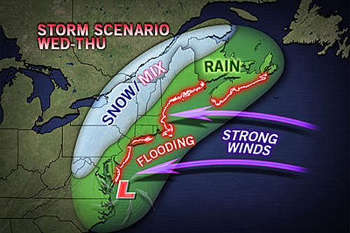
Tuesday update: A looming nor’easter will begin to strike the East End Wednesday afternoon, with winds increasing up to 60 mph gusts, according to the latest National Weather Service forecasts.
Rainfall will be less than one inch in total, less than originally expected, said meteorologist David Stark. The biggest concerns will be winds and coastal flooding.
“[The wind] is one of our biggest concerns. It could bring down more trees, cause more power outages,” Mr. Stark said.
Low temperatures will also make things difficult for those without power. Weather experts are predicting a high temperature in the 40s on Wednesday as the nor’easter hits.
“Its going to be one of those raw days,” Mr. Stark said. “Make sure you can stay warm.”
The storm will weaken and leave the area by Thursday evening into Friday, he said.
Original story: A “significant” nor’easter is expected to bring gusty winds, rain and coastal flooding to Long Island Wednesday evening, battering an area already dealing with power outages and gas shortages in the wake of superstorm Sandy, according to National Weather Service forecasts.
The storm could hamper clean-up efforts on the North Fork, and may knock down branches and trees already weakened by Sandy last week, weather experts said.
The nor’easter is expected to form over the southeastern coast Tuesday and strike the east coast Wednesday evening into the overnight hours, said David Stark, a meteorologist with the National Weather Service in Upton.
Forecasts show the storm will pack sustained winds of 30 to 40 mph, with gusts between 45 and 60 mph, Mr. Stark said.
“There is a concern that if these winds materialize we could see more power outages and downed trees,” he said.
Mr. Stark said the North Fork will see between 1 and 2 inches of rain Wednesday evening and “moderate coastal flooding.”
Sandy’s devastation, especially along the south shore of Long Island where protective sand dunes were wiped away, makes it difficult to predict how bad the surge’s effects will be, Mr. Stark said, adding that the Long Island Sound and South Shore will likely see worse flooding.
There is some uncertainty in the forecast because the storm has not formed yet, and the effects will be less severe if the storm heads off the coast. Updated information is expected once the nor’easter forms Tuesday.
“The way it looks right now, [the storm’s track] will be close enough that we’re going to see some of those winds,” Mr. Stark said.


