
Thirteen inches of snow hits the North Fork
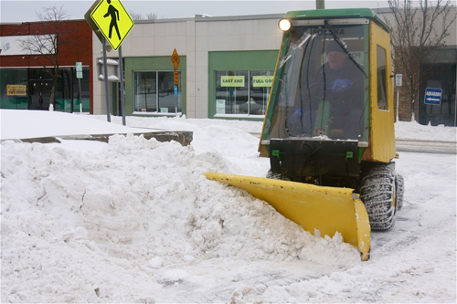
UPDATE, Wednesday, 9:30 a.m.: Riverhead Town highway crews are plowing out the backroads this morning, finishing up developments around town, according to the highway superintendent.
“The main roads should be passable,” said George “Gio” Woodson. “Hopefully we should be done by mid-afternoon.”
Highway workers will be sanding and salting the roads once they’re plowed, Mr. Woodson said. The wind overnight posed a problem for crews, as snow drifts blew back onto local roadways once they were plowed.
“The wind put a damper on us, but it’s slowed down now,” Mr. Woodson said. The highway superintendent also recommended residents stay inside if possible.
“If you don’t have to go anywhere, don’t go anywhere,” he said. “People just gotta drive slow … otherwise you’re just making it unsafe for everybody out there.”
UPDATE, Wednesday, 8 a.m.: A winter storm dumped more than a foot of snow overnight as residents woke up this morning to bitter cold temperatures as they begin to dig out. According to the National Weather Service, the high temperature today will be about 19 degrees. Wind chill values are as low as -12.
The highest recorded snow total locally was in Jamesport which saw 13 inches as of 7 a.m., according to the NWS. Flanders recorded 10 inches of snow, while Riverhead saw 9.6 inches as of 4:30 a.m., according to the NWS snowfall totals.
“The storm was actually pretty much exactly what we were expecting,” said meteorologist Lauren Nash. A Winter Storm Warning is in effect until 9 a.m. for the East End, she said.
Winds will gust as much as 38 miles per hour. Winds should decrease toward the afternoon.
Riverhead Town Supervisor Sean Walter lifted the state of emergency at 8 a.m. this morning, and Riverhead Town Hall will have a delayed opening at 10 a.m.
There are no current power outages in town, according to PSEG Long Island.
Check back for an update on road conditions.

UPDATE, Tuesday, 8 p.m.: Six inches have already fallen on Riverhead as of 6 p.m., according to National Weather Service readings in town, with the heaviest snow still set to come during the overnight hours.
Riverhead Town Supervisor Sean Walter has issued a State of Emergency for the town and urged residents to stay indoors and avoid driving.
UPDATE, Tuesday, 5:45 p.m.: Governor Andrew Cuomo declared a state of emergency late this afternoon as blizzard-like conditions begin to pound the area.
“This winter storm will bring a one-two punch of snow and extreme cold,” Gov. Cuomo said in a press release. “I urge all those in the affected regions to exercise caution, and avoid travel if possible.”
UPDATE, Tuesday, 5 p.m: Riverhead Town Highway Superintendent George “Gio” Woodson is warning drivers to stay off the roads unless absolutely necessary during the storm and to move parked vehicles off the streets and into driveways.
Mr. Woodson said the highway department had already salted and put brine solution on the roads to prevent them from icing over, and is plowing areas.
“We’re keeping the main roads open, maybe do a couple of the developments,” he said. “We’re just trying to stay ahead of the eight-ball.”
UPDATE, Tuesday, 11 a.m: Tuesday night’s winter storm could dump as much as two inches per hour on the Riverhead area overnight, weather experts said.
The storm is following the National Weather Service’s predictions so far, and snowfall totals are on track to reach between 10 and 14 inches for the Riverhead area by tomorrow morning, said meteorologist Tim Morrin
“The storm is developing as we speak,” Mr. Morrin said.
Light snowfall hit eastern Long Island this morning and will continue throughout the day, with three inches expected by 5 p.m.
“The snow is sticking on untreated roads and surfaces,” Mr. Morrin said. “Even a coating will make things very slippery and it will only get worse through the afternoon hours.”
Conditions will deteriorate overnight with the heaviest snow coming between 9 p.m. and 6 a.m. Wednesday. Visibility could be less than a quarter of a mile.
The National Weather Service has issued a winter storm warning starting at noon today and lasting until 6 a.m. Wednesday for Long Island, Westchester County, northern New Jersey and part of southern Connecticut.
UPDATE: The National Weather Service increased its snowfall forecast for Tuesday into Wednesday, upping the possible total to 10 to 14 inches.
Eight to 10 inches had been expected previously. Though meteorologist Ashley Sears said that precipitation that had previously been expected to hit offshore looks to be hitting eastern Suffolk County.
The winter storm warning begins at noon on Tuesday and is expected to last until 6 a.m. on Wednesday.
ORIGINAL: Riverhead could be in line for its second snowfall of 2014, as the National Weather Service is predicting anywhere from six to eight inches of snow Tuesday afternoon into Wednesday morning.
The NWS has issued a winter storm watch from Tuesday afternoon through late Tuesday night for Long Island, Westchester County, northern New Jersey and part of southern Connecticut.
Meteorologist Joe Pollina said on Monday morning that snowfall should get “steadier and heavier tomorrow afternoon,” ending sometime late Tuesday night for most of Long Island.
But snowfall could last into Wednesday for those on the East End.
“The twin forks could see lingering showers and flurries into early Wednesday morning,” he said.


