
With icy air comes a frozen Long Island Sound
You could be forgiven for thinking this February has been colder than usual. It has. But just how much colder — a staggering 10.8 degrees below normal — has surprised even meteorologists, who say the month is on track to become Long Island’s coldest February on record.
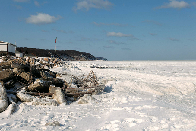
The consistent cold snap has caused a rare phenomenon, one not seen for nearly 40 years: Long Island Sound is freezing over, so to speak.
“I’ve never seen it freeze over like this,” said Dominick Mavellia of Southold, whose home overlooks the frozen waters. “It looks like Antarctica … it’s quite beautiful.”
Ice reached thousands of yards into the Sound this week from Long Island’s North Shore, marking the farthest icing of the water in years, residents and experts said. The Sound never completely freezes over due to ship traffic and tides, but this level of icing is historically significant — though no official sources measure the reach of ice in the saltwater body.
This year’s icy Sound has caused some problems for the U.S. Coast Guard, among others.
“We haven’t really been out in the Sound for about a week,” said Boatswain’s Mate 2nd Class Tyler West of the Coast Guard’s Long Island Sector, based in New Haven, Conn.
Mr. West said de-icers have kept the shipping channels open in New Haven harbor and that ship traffic has prevented the entire Sound from freezing. But he said the docks around the station are clogged with ice.
“Right now we’re pretty well iced in,” he said. “Our station boats can’t break through the ice.”
This month’s cold snap has been historic in its consistency, said National Weather Service meteorologist John Murray.
“This is an extreme low, and that’s significant when you’re talking about a monthly temperature,” he said. Normally, he explained, cold days average out with warmer ones during less brutal winters.
But this February, the cold days have averaged with even colder ones. That’s thanks to a prolonged dip in the Canadian jet stream that has allowed arctic air from Canada to blast the area.
Not even Sunday’s warmer temperatures did much to change the overall numbers, Mr. Murray said.
“It was just one day,” he said. “The low temperatures at night have all been in the single digits.”
Through Sunday, the average daily temperature at the National Weather Service’s station at Islip was 21.5 degrees, far below normal.
That average is also much lower than the previous February cold record, set at 27.1 degrees in 2007.
“If we end the month at 21.5, it would be the coldest February in the history of the station at Islip,” dating back to 1984, Mr. Murray said.
Stony Brook University oceanography professor Henry Bokuniewicz said, “It takes a severe event to cause the Sound to freeze,” adding that it would be impossible for Long Island Sound to freeze over completely.

