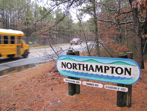
Northampton: Has it every truly existed?

If you drive down Lake Avenue, you’ll travel from Riverside at one end of the road to Northampton at the other.
At least that’s what the welcome signs say.
But the president of the recently formed Riverside Revitalization Community Coalition thinks his hamlet is getting shorted.
Bill Schaw of Riverside believes the homes around Wildwood Lake should be considered Riverside as well.
“That whole area used to be considered Riverside,” he said. “The name Northampton was the name of a development there, not the hamlet.”
Different hamlet names or redrawn boundaries wouldn’t make a difference in terms of ZIP code; the Flanders, Riverside and Northampton communities in Southampton Town all use Riverhead’s 11901 ZIP code. And for the most part, it wouldn’t affect taxes either, since all three communities are in the Riverhead School District, the Riverhead Library District and the Flanders-Northampton Ambulance District.
The one major difference is in fire districts. Most of the area is covered by the Flanders Fire District, but the Riverhead Fire District covers what is often considered Riverside and Northampton, essentially cutting a hole in the Flanders Fire District, which covers the areas west of the jail and the area around Suffolk Community College, according to a Southampton Town map of fire district boundaries.
There’s also a Flanders Water District, a Flanders Lighting District and a Riverside Water District, which also covers the homes along Wildwood Lake.
Chris Sheldon of Northampton — assuming there is a Northampton — disagrees with Mr. Schaw. It was his late father, Leonard Sheldon, who built the residential development around Wildwood Lake that Mr. Schaw refers to.
“The development was never named Northampton,” Mr. Sheldon said. “It was called Wildwood Lake at Northampton. If you look up the map, it was called Wildwood Lake Development Corp.”
Mr. Sheldon said that over the years, the Northampton name has stuck with the community. The Hampton Hills golf course was originally called the Northampton Golf Club when it was built in the 1960s and the U.S. Postal Service recognized the name Northampton in the 11901 ZIP code when those codes were created in the 1960s, Mr. Sheldon said.
Also, he said, a civic group called the Flanders-Northampton Alliance was created around 1980 and from it came the name of the Flanders-Northampton Volunteer Ambulance, which also serves Riverside.
In addition, Mr. Sheldon said, the name Northampton is recognized by the Census Bureau, the New York State “I Love New York” map, Southampton Town, Google Earth and even the state Department of Motor Vehicles.
Mr. Sheldon acknowledges that before the Northampton name caught on, the whole area was called Riverside. But he doesn’t think there’s any going back.
“My driver’s license says I’m from Northampton,” he said, adding that if one wanted to go further back in history, “It was also called no man’s land; there was nothing there.”
Mr. Schaw says that if a community is going to be named after a development project, you might also want to consider a big chunk of what is commonly called Flanders to be part of Riverside.
He said a development in the 1930s called Riverside Estates stretched all the way to Pleasure Drive.
“So the Big Duck would be in Riverside,” he said.
Gary Cobb, president of the Flanders Village Historical Society, said the name Flanders can be found on maps as far back as 1797. But the boundaries of what was considered Flanders are not as clear, because it was never an incorporated municipality.
The business area of Flanders initially stretched from eastward Chauncey Road, near the Big Duck, to the area now occupied by a junk yard along Flanders Road.
He said it was referred to in deeds and records as Flanders Village, although it was not an incorporated village.
Mr. Cobb said he believes the Riverside Estates development got its name more from the fact that it was alongside the river than because the area was ever called Riverside.
The first boundary to differentiate Flanders from the rest of the area would emerge when Flanders School District No. 4 was created around 1812. Mr. Cobb was not certain of the boundaries of that district, which was one of about 13 smaller districts that became the Riverhead Central School District in the 1950s.
He’s seen newspaper accounts from more than 100 years ago that refer to Riverside, but as for Northampton, he said, “I have no idea.”
Southampton Town actually created a hamlet map in 2010 that outlined unofficial boundaries for 17 hamlets in the town. At the time, town officials said the boundary map was being created for planning, address and civic identification purposes, and would have no impact on taxing districts.
On that map, Riverside becomes Northampton just south of Woodhull Avenue, which is where the “Welcome to Northampton” sign is. It also shows Riverside extending as far west as the town border on County Road 94 and as far east as County Road 105, with the residential neighborhoods just south of Flanders Road and along County Road 104 included as well.
Vince Taldone, president of the Flanders, Riverside and Northampton Community Association, which put up the various hamlet signs using county grant money, said FRNCA used the town boundary map to determine where to put the signs.
“If it’s determined that this is incorrect, we’ll move it,” he said. “Do a petition. We’re not going to oppose it. FRNCA has taken no position on this issue.”


