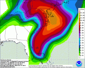
Sandy to make its presence known starting Sunday evening


What’s being dubbed ‘Frankenstorm’ — the combination of Hurricane Sandy captured by an upper level trough coming from the Midwest — should begin to be felt on Long Island sometime late Sunday, with Sandy expected to make landfall as a Category 1 hurricane, weather officials said.
And it’s expected to stick around for awhile, at least through Tuesday, said Dan Hoffman, a meteorolgist with the National Weather Service station in Upton.
“Right now it’s forecast by the hurricane center to pass a little south of NYC and Long Island,” Mr. Hoffman said, “It’s important to not focus exactly on the center; this is a very large, powerful and expanding storm, so its effects will be felt hundreds of miles away. It’s expanding in size, over a larger area.
“This will be a longer duration event,” he continued. “I know people were comparing it to Irene, but if you remember with Irene, we had blue skies the day before and blue skies the day after. The worst of this may be half a day, but the overall impacts, which will be significant, will potentially last for a couple of days.”
Officials have been warning of heavy rain, damaging winds and the potential for coastal flooding from storm surges, as well as plenty of power outages.
As of 11 a.m. Friday, Hurricane Sandy was a Category 1 storm carrying 80-mph winds over the Northwest Bahamas, and growing in size.
The storm is expected to parallel the East Coast and then get caught by the trough, which will “draw the storm back to the coast,” Mr. Hoffman said.
Local highway departments and police forces were already gearing up for the storm Friday. And Riverhead Supervisor Sean Walter on Friday called a 3 p.m. Saturday meeting with the town’s police and emergency officials to hammer out plans.
School district superintendent Nancy Carney said she would also be at the meeting.
“We are monitoring the storm and we are prepared to assist the town and/or Red Cross in any way needed,” she said. “We are prepared in the district and we will be ready to open the high school as an evacuation center if it is needed.”
In the meantime, Riverhead highway department workers were getting the department’s many pieces of equipment and machinery ready, said Superintendent George (Gio) Woodson.
“We’re fueling up the trucks and greasing the equipment,” he said. “We’re getting water pumps ready in case we have flooding and lining up traffic cones and barracades. We’ll see what happens, but it may be pretty rough out there early next week.”
Mr. Woodson planned to place five highway department crews at strategic points across the town.
“It’s unbelievable,” he said. “So much for the hurricane season being over. But you do what you’ve got to do.”
In Southold, Police Chief Martin Flatley had been tracking the storm since 7 a.m.
“The model we’re looking at has it making a turn to the west and making landfall in southern New Jersey,” he said. “But the models have been changing every four to five hours.
“Even if it takes that path you know we’re going to get some wind and rain,” Chief Flatley said. “Flooding in low-lying areas could be one of our biggest problems.”
The chief said he’s heard from the Cross Sound Ferry Company, which said it may have to suspend service between Orient and New London on Monday.
The town has been in constant contact with the Suffolk County’s Fire, Rescue and Emergency Services Department, which operates the county’s emergency operations center in Yaphank.
Southold’s emergency management team, which includes Supervisor Scott Russell, Greenport Mayor David Nyce, Highway Superintendent Pete Harris and representatives from Eastern Long Island Hospital in Greenport, is scheduled to next meet this afternoon at 2 p.m.
As for the two storms meeting each other — which isn’t a rare event, though it doesn’t often happen along the coast — Mr. Hoffmans said that process “is not instantaneous.”
“They’ll start interacting later this weekend and then be completely merged…It will happen over a period of hours to around a day or so. Right now, that trough is pretty much over the northern Great Plains.
The cold front associated with that trough extends from the eastern Great Lakes through the Ohio Valley.”


