
Update: Slushy ‘nuisance’ storm forecasted for Monday
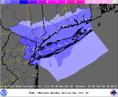
Update: An updated weather forecast shows the North Fork will get about an inch of slushy snow from Monday’s snowstorm.
The worst of the snowfall has moved south off Long Island and won’t affect the area, according to the forecast.
Original story: A small winter storm will blow through the East End Monday afternoon, bringing slippery driving conditions and about three inches of snow to Riverhead, according to the latest National Weather Service forecasts.
The storm is expected to hit the area between noon and 1 p.m., said Tim Morrin, a meteorologist with the National Weather Service station at Upton.
The National Weather Service has issued a Winter Weather Advisory for the area.
“As we speak the snow is working its way up along the New Jersey coast,” Mr. Morrin said Monday morning.
The storm will bring wet snow or a wintery mix of snow and rain at first during the daylight hours, with not much accumulation on the roads, he said. But the precipitation will switch to snow and begin piling up on the road later in the day and into the evening commute, he said.
“We could see some slick driving as we head into the evening,” Mr. Morrin said. “[The storm is] not a big event, but something that’s going to be a nuisance.”
The snow will continue to fall until about 10 p.m. and will taper off by midnight, he said. Drivers are advised to be extra cautious during their evening commutes, when the roads will be the slickest, according to National Weather Service forecasts.