
Updated forecast: Snowfall predictions increase again
UPDATE, SATURDAY 5:45 P.M.: The National Weather Service said snowfall total is predicted to hit 24 to 28 inches on Long Island, with 20 to 25 inches landing on the North and South Forks. The blizzard warning remains in effect until 7 a.m. Sunday.
Winds are expected to be 25 to 35 miles per hour, with gusts up to 50 mph. Visibility is “one quarter mile or less at times,” the update states, with whiteout conditions likely. The NWS added travel is “extremely dangerous,” and that “secondary and tertiary roads may become impassable.”
UPDATE, SATURDAY 11 A.M.: The National Weather Service has increased its predicted snowfall total for Long Island yet again, foreseeing anywhere from 18 to 24 inches of snow on the island.
The East End is still expected to get less than the western part of Long Island, however “widespread blizzard conditions” are still likely.
“Strong winds may down power lines and tree limbs,” the update states.
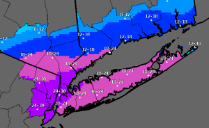
A map created by the NWS and posted around 11 a.m. shows that only the far eastern tip of Long Island can now expect to see 12 to 18 inches of snow — points east of Napeague on the South Fork, and points east of Greenport on the North Fork.
UPDATE, SATURDAY 6:15 A.M.: After predicting 10 to 18 inches of snow for Long Island yesterday — with lesser totals on the East End — the National Weather Service upped its forecast for Saturday’s snowfall to the 15 to 20-inch range.
“Lesser amounts over the forks region of Long Island,” the NWS states, though Riverhead and the North Fork are both listed in the 12 to 18-inch range on an NWS map posted around 3:30 a.m. Saturday.
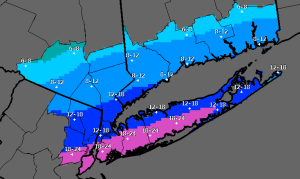 Predicted snowfall totals have risen north overnight as the storm has made its way up the coast.
Coastal flooding also remains a big concern, as a coastal flood warning is in effect from 7 a.m. Saturday to 2 p.m. A coastal flood advisory is in effect from 9 p.m. Saturday through 1 a.m. Sunday.
High tide this morning — slated for around 11:30 a.m. in Riverhead — is expected to be up to three feet higher than normal.
“Moderate” flooding is expected in Riverhead at the 11:23 p.m. high tide tonight.
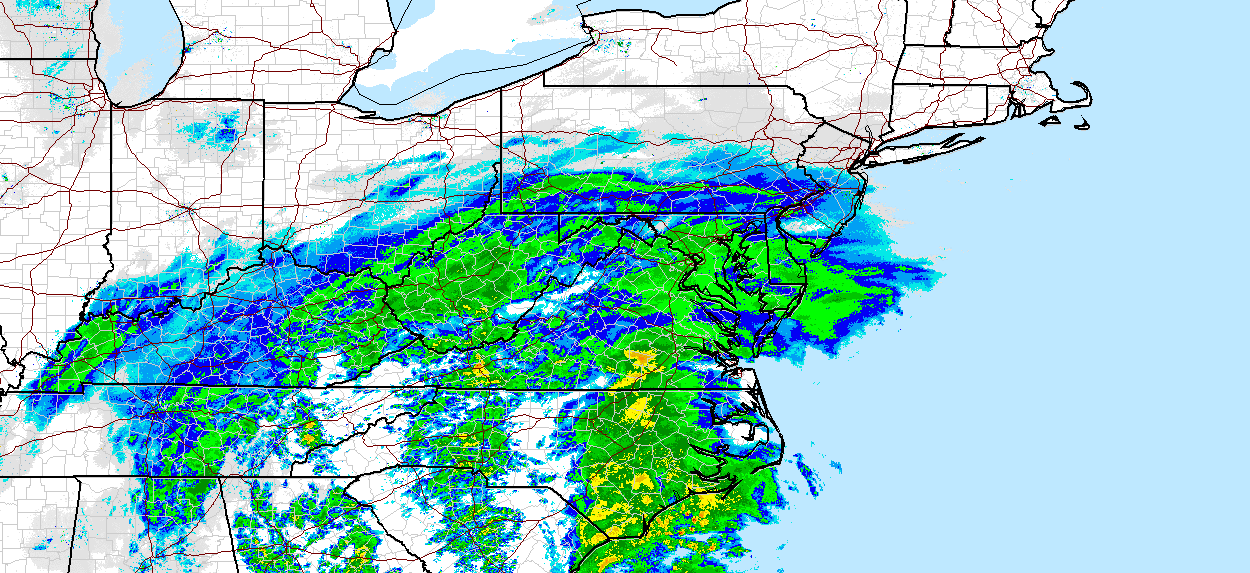
ORIGINAL STORY: Saturday’s winter storm — set to be the first significant snowfall of the season — is moving faster than expected. Now forecasts from the National Weather Service show it could hit harder than expected too.
The NWS has issued a blizzard warning in effect from midnight Saturday through 7 a.m. Sunday, warning that up to a foot of snow could be dumped on the East End, said meteorologist David Stark.
“It’s not too far away now to the south,” he said, noting Delaware is already feeling the storm’s effects. “This is a nor’easter. We’re going to be kind of the cold side that gives you the snow and the winter storm conditions.”
Snow could begin falling by midnight tonight, picking up in intensity with heavy snow and high winds throughout the night, forecasts now show. By daybreak, our area could see gusts of 50 mph and a couple of inches of accumulation, Mr. Stark said.
According to the NWS, 10 to 18 inches is predicted in total, with the storm continuing through the evening. However, according to Mr. Stark, snow could fall in the 4 to 8-inch range on the East End due to the potential for sleet that could be mixed in at times during the afternoon.
Residents are being advised to stay indoors as roadways could be treacherous.
Related: Local closures, cancellations and delays
Another potential problem: a storm surge. A full moon combined with the high winds could push Saturday night’s high tide 2 to 3 feet above normal, Mr. Stark said. Shorelines could see beach erosion and lower elevations may be washed over by the high tides.
The NWS has issued a coastal flood warning lasting from 5 p.m. Saturday to 1 p.m. Sunday.
But there is good news. The storm’s fast approach means it should leave sooner than expected too. By Saturday night, the heavy snowfall should gradually decrease, though high winds could lead to blowing snow.
Clouds may begin clearing as early as Sunday morning, with winds dying down and temperatures rising into the upper 30s.
“We’ll start to see a lot of melting going on,” Mr. Stark said. Monday and Tuesday also look warmer, with sun and highs near 40 on Monday and a high of 46 on Tuesday.
“The trend is going up,” Mr. Stark said.


