
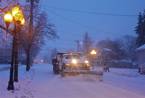
NWS: Blizzard warning upgraded, up to 30 inches expected
Update 10:30 p.m. Sunday: Suffolk County Community College has cancelled all classes for Tuesday and Wednesday.
Update 7:30 p.m. Sunday: Gov. Andrew Cuomo is urging commuters to work from home Monday or plan to leave work early Monday because roads — including the Thruway, I-84 and the Long Island Expressway — and public transit networks, including: the LIRR, PATH, Metro North Railroad, and MTA subways and buses may be closed ahead of the evening commute.
Update 7 p.m. Sunday: Stony Brook University has cancelled all classes for Monday and Tuesday.
Update 4:30 p.m. Sunday:
Riverhead could see between 20 to 30 inches of snow by Tuesday, according to a blizzard warning issued by the National Weather Service.
The NWS is predicting a “crippling and potentially historic blizzard” with snowfall rates between 2 to 4 inches per hour.
“Light snow will begin Monday morning with accumulations of 1 to 3 inches possible by the evening rush,” the NSW warning states. “Snow will pick up in intensity Monday evening with the heaviest snow and strongest winds from about midnight Monday night into Tuesday afternoon.”
The blizzard warning is in effect between 1 p.m. Monday until midnight Tuesday. Winds will be blowing north from 30 to 40 miles per hour with gusts as high as 65 MPH.
“[There will be] life-threatening conditions and extremely dangerous travel due to heavy snowfall and strong winds with whiteout conditions,” the NWS warning states. “Secondary roads may become impassable. Strong winds may down power lines and tree limbs.”
Temperatures are expected to remain below freezing into Tuesday afternoon with a low of about 20 degrees forecast for the area.
Check back with riverheadnewsreview.com for up-to-date weather details, including school closings, over the next several days.


